


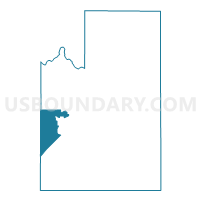
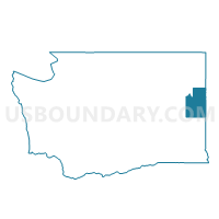
Voting District 7009, Spokane County, Washington
About
Outline

Summary
| Unique Area Identifier | 689241 |
| Name | Voting District 7009 |
| County | Spokane County |
| State | Washington |
| Area (square miles) | 62.14 |
| Land Area (square miles) | 61.97 |
| Water Area (square miles) | 0.17 |
| % of Land Area | 99.73 |
| % of Water Area | 0.27 |
| Latitude of the Internal Point | 47.53868190 |
| Longtitude of the Internal Point | -117.77632200 |
Maps

Graphs
Select a template below for downloading or customizing gragh for Voting District 7009, Spokane County, Washington


Neighbors
Neighoring Voting District (by Name) Neighboring Voting District on the Map
- Voting District 7010, Spokane County, WA
- Voting District 7200, Spokane County, WA
- Voting District 9004, Spokane County, WA
- Voting District 9009, Spokane County, WA
- Voting District 9100, Spokane County, WA
- Voting District 9101, Spokane County, WA
- South Reardan Rural Voting District, Lincoln County, WA
- Sprague Rural Voting District, Lincoln County, WA
- Waukon Voting District, Lincoln County, WA
Top 10 Neighboring County Subdivision (by Population) Neighboring County Subdivision on the Map
- Cheney-Medical Lake CCD, Spokane County, WA (24,273)
- Airway Heights CCD, Spokane County, WA (13,183)
- Davenport CCD, Lincoln County, WA (4,858)
- Amber-Cheney South CCD, Spokane County, WA (3,327)
- Odessa CCD, Lincoln County, WA (2,998)
Top 10 Neighboring Place (by Population) Neighboring Place on the Map
Top 10 Neighboring Unified School District (by Population) Neighboring Unified School District on the Map
- Cheney School District, WA (33,075)
- Medical Lake School District, WA (11,244)
- Reardan-Edwall School District, WA (4,260)
- Sprague School District, WA (675)
Top 10 Neighboring State Legislative District Lower Chamber (by Population) Neighboring State Legislative District Lower Chamber on the Map
Top 10 Neighboring State Legislative District Upper Chamber (by Population) Neighboring State Legislative District Upper Chamber on the Map
Top 10 Neighboring 111th Congressional District (by Population) Neighboring 111th Congressional District on the Map
Top 10 Neighboring Census Tract (by Population) Neighboring Census Tract on the Map
- Census Tract 104.02, Spokane County, WA (6,937)
- Census Tract 139, Spokane County, WA (5,752)
- Census Tract 141, Spokane County, WA (5,507)
- Census Tract 142, Spokane County, WA (3,327)
- Census Tract 9602, Lincoln County, WA (3,115)
- Census Tract 9604, Lincoln County, WA (2,998)
- Census Tract 138, Spokane County, WA (2,776)
Top 10 Neighboring 5-Digit ZIP Code Tabulation Area (by Population) Neighboring 5-Digit ZIP Code Tabulation Area on the Map
- 99004, WA (18,376)
- 99022, WA (8,820)
- 99011, WA (2,776)
- 99029, WA (1,289)
- 99032, WA (691)
- 99008, WA (641)